

Kyger Creek Power Plant – Geotechnical Drilling Project
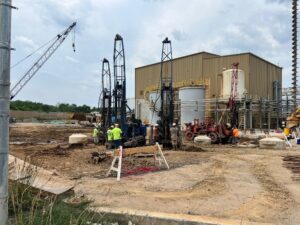
The Kyger Creek Power Plant is located in Cheshire, Ohio (Gallia County) and began servicing the area in 1955. It is a 1.08-gigawatt, 1,086 (MW) coal-fired plant and is operated by the Ohio Valley Electric Corporation (OVEC). This plant has 5 units supplied by electricity for the Portsmouth Gasseous Diffusion Plant in Piketon, Ohio as well its counterpart plant, the Clifty Creek Power Plant in Madison, IN. Bowen Engineering is on site and has begun construction of a new Process Building as well as Bio Reactor tanks. Bowen hired Goettle to install the pier foundation system who in turn hired…
So you want to become a Landscape Architect?
Written by: Corey Armstrong Corey Armstrong started in the landscape industry as a teenager working for a friend and fellow classmate doing odd-jobs, planting shrubs and mulching. Later, summer mornings before his senior year in high school evolved into riding in the front passenger seat of an old pickup truck while sketching on Dunkin Donut napkins, this experience serving both as initial design studio time and unofficial construction documentation for much larger backyard renovations, poolscapes, and elaborate planting layouts in local suburban neighborhoods. This modest introduction to design/build would lead Corey to completing his BS in Landscape Architecture from West Virginia…