

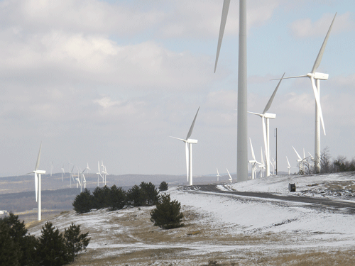
The NedPower Mount Storm Wind Power Project is located about 120 miles west of Washington, D.C. in Grant County, West Virginia. The project consists of 132 wind turbines along 12 miles of the Allegheny Front, and can generate enough electricity to serve 60,000 homes and businesses. Triad Engineering performed multiple environmental services required to support the continuously developing, large-scale wind power project at both Phase I and Phase II project areas. Multiple contracts for various areas of the project were performed in a timely manner to allow the project to progress at a rapid rate without delay. Triad performed Wetland Delineation Studies, Environmental Site Assessments, and Environmental Permitting. In addition, various Surveying, Civil Design, and Construction Management Services were performed in support of these environmental services.
Beginning in June 2006, Triad began performing Wetland Delineation Services for the NedPower Mount Storm Wind Power Project. Since then, Triad has performed over 10 different Wetland Delineation Studies for various aspects of the project. This included both Routine Determinations and Preliminary Investigations in general Accordance with the 1987 U.S. Army Corps of Engineers (Corps) Wetland Delineation Manual. The largest of the Routine Wetland Delineation Studies was for the Phase II Project Area consisting of approximately 50 turbines and over 4 miles of access roads. This investigation of approximately 3 square miles of unimproved terrain identified 150 acres of emergent/forested wetlands and 2,000 linear feet of perennial and intermittent stream channels, which was demarcated in the field with flagging and located as part of a field-run survey.
The field-run survey of the delineated wetland/waterway limits at the Phase II Project Area occurred in April and May 2007. Primarily GPS and some terrestrial surveying methods were employed to complete this work. The survey equipment utilized during the field run survey consisted of a Topcon Total Station and a Topcon GMS-2 GIS/GPS sub-meter receiver. Relative to the existing survey controls available on this project site, locations obtained utilizing the Topcon Total Station are accurate within 1 foot, while locations obtained utilizing the GPS surveying methods are generally accurate within 3.28 feet.
Triad obtained an official Jurisdictional Determination from the Pittsburgh District Corps for the Routine Wetland Delineation Study for Phase II Project Area. In addition, for the various other wetland delineation activities that the project required, Triad obtained verbal regulatory concurrence from the Corps during various on-site meetings.
Triad performed Environmental Permitting Services for a required stream crossing within the Phase I Project Area. This included the associated Civil Design and Construction Management/Monitoring Services. The permitting process entailed preparing and submitting a West Virginia Division of Natural Resources (WVDNR) Stream Activity Application and a Pre-Construction Notification (PCN) as part of the requisite information required by the Corps for coverage under Nationwide Permit (“NWP”) 14. As part of the PCN preparation, Triad designed the new culvert crossing and produced plan and profile construction drawings. Upon receipt of the required permits and the initiation of construction, Triad also provided on-site construction management/monitoring for the culvert installation within jurisdictional waters of the U.S.
Triad conducted multiple Phase I Environmental Site Assessments (ESAs), for the NedPower Mount Storm Wind Power Project. Triad first conducted environmental assessment work on the 460-acre Grafton Coal Company Property in February 2007. In April 2007, a Phase I ESA was conducted on the Phase II Project Area, which included nine parcels of land. In September 2007, Triad performed an additional Phase I ESA for the Phase I Project Area since the original Phase I ESA by others was outdated. The Phase I Project Area included numerous parcels totaling approximately 4,900 acres and a string of wind turbines approximately 10 miles long. Triad inspected all turbine locations, access roads, and paths of the electrical collection system on foot. In April 2008, Triad was once again requested to perform a Phase I ESA for two newly-leased properties in the Phase I Project Area. Factoring in cost, time restraints, and limited access to the site, Triad inspected the entire project site via helicopter, saving the customer considerable time and reducing fees for this phase of work.